Geography |
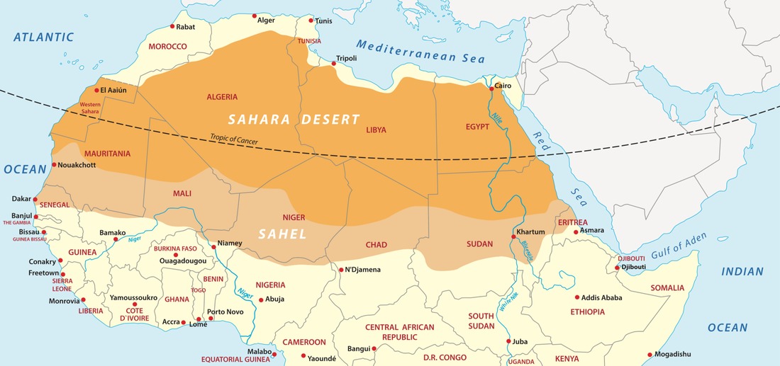
Sahara covers large parts of Algeria, Chad, Egypt, Libya, Mali, Mauritania, Morocco, Niger, Western Sahara, Sudan, and Tunisia extends over 9 million square kilometers. It also covers 25% of Africa continent. The Sahara is bordered by the Atlantic Ocean on the western edge, the Atlas Mountains and the Mediterranean Sea to the north, the Red Sea on the east, and the Sudan and the valley of the Niger River on the south.
|
Most of the Sahara is undeveloped and features are varied topography. Most of its landscape has been shaped over time by wind and includes sand dune, sand seas called ergs, barren stone plateaus, gravel plains, dry valleys and salt flats. There are also several mountain ranges within the Sahara and many are volcanic. There is only one river that is permanent river in the desert is the Nile River that flows from Central Africa to the Mediterranean Sea.
|
|
|
The central Sahara is hyperarid, with sparse vegetation. The northern and southern reaches of the desert, along with the highlands, have areas of sparse grassland and desert shrub, with trees and taller shrubs in wadis, where moisture collects. In the central, hyperarid region, there are many subdivisions of the great desert: Tanezrouft, the Ténéré, the Libyan Desert, the Eastern Desert, the Nubian Desert and others. These extremely arid areas often receive no rain for years.
|

|
|
To the north, the Sahara skirts the Mediterranean Sea in Egypt and portions of Libya, but in Cyrenaica and the Maghreb, the Sahara borders the Mediterranean forest, woodland, and scrub eco-regions of northern Africa, all of which have a Mediterranean climate characterized by hot summers and cool and rainy winters. To the south, the Sahara is bounded by the Sahel, a belt of dry tropical savanna with a summer rainy season that extends across Africa from east to west.
|
|
